A moment after reaching the summit of Ma’aleh Akrabim – “Scorpion Pass” – there was silence. Each of us took a deep breath, raised a palm to shade the eyes and looked east. From the top of the ascent, one can see the verdant banks of the Nahal Zin, Mount Zin and the expanse of the Arava Desert. The view is mesmerizing. Below us winds a narrow road, descending south in 18 hairpin turns. This is one of the most beautiful and singular roads in Israel, but it has been closed for over five years, and driving on it is prohibited. But people are attracted to the forbidden.
Ten minutes later, we had traversed 2 kilometers down the slope, slowly navigating four switchbacks and parking at the Ma’aleh Akrabim lookout point, which offers a fine view of the Roman-era part of the road, the twists and turns of the road beyond, the famous “frog rock” and below, the ruins of the Rogem Zafir fortress. It is hard to leave this little observation point. Signs explain the importance of the location and a bit of its history. You know Snakes and Ladders? This is the real version.
I drove to Ma’aleh Akrabim with Israel Nature and Parks Authority personnel to understand why the pass is closed, how it’s possible that an ancient road that connects biblical stories to archaeology, history, landscape, heritage and modern Israeli history, is closed to travelers. Why is a beautiful road that all agree has massive tourism value not open for travel? The Nature and Parks Authority’s involvement and influence significant, because the longer road that Ma’aleh Akrabim is part of, passes through nature reserves – Mishor Yamin, Machtesh Katan, Machteshim Ein Yahav and the Judean Desert.
The winding expanse of Ma’aleh Akrabim.
Ma’aleh Akrabim is not a transit route. It is a destination unto itself. Those who have traveled it in the past know this well. Those who haven’t face a difficult dilemma. They can get there, but it’s illegal. Signs at both ends of Route 227 clarify this in the most unmistakable manner. And yet, there is currently no physical barrier impeding the visit. Any car can reach the monument to the engineers who paved the road, shaped like a rook chess piece, and slalom down Ma’aleh Akrabim to the Arava Desert. It’s a dangerous drive, as the shoulders are crumbling following years of neglect and closure, but it’s a thrilling experience.
The road runs some 30 kilometers from the northwestern end to the Ein Hatzeva Interchange on Route 90. It is not maintained, there are no guardrails and, according to authorities, it is unfit for vehicular traffic. What needs to happen for Route 227 to be reopened to the general public, then?
Wildlife next to the bed of Nahal Zin.
Everyone would benefit: Nature lovers and hikers would have another, wonderful, destination. The area would have more visitors. Residents of Yeruham would have another attraction to offer their guests. The big question is who is preventing the road from reopening, and why the obvious move hasn’t happened yet.
Biblical and Roman past
Ma’aleh Akrabim is mentioned in the Book of Numbers – “and your border shall turn about southward of the ascent of Akrabbim, and pass along to Zin,” (Numbers 34:4) – and a few other places in the Bible as the southern border of the Land of Israel, the border of the Kingdom of Judah and a route from the Judean Hills and Hebron to the Arava Desert and the Red Sea. While there is no definitive identification that this is the same ascent, few ancient roads descend from the mountains to the Arava.
A work camp in the lowest place on earth is Israel’s latest tourist attraction
We walked to Jerusalem on ‘one of the most beautiful train routes in the world’
Where Jesus meets flamingos
Archaeological excavations at the site uncovered numerous finds from the Roman and Byzantine periods, especially the second century C.E. The Romans paved the pass, putting in the series of switchbacks to ease travel, and erected walls and built stairs. At the top of the road stands Zafir fortress, a square fortress that was built in the third century and used as a guard station in the Byzantine period. At the bottom of the lower end of the hill stands the small Rogem Zafir fortress, and next to it the remains of a khan, or caravansary.
The road in its current form was built by the British in 1927, following the beautiful turns of the Roman route. It was paved to connect two British camel cavalry police stations in the area.
In November 1948, the Israel Defense Forces conquered the road as part of Operation Lot. Six months later, Golani Brigade forces used it on their way south to Eilat. They were followed by the Alexandroni Brigade, on its way to capturing Ein Gedi and the shore of the Dead Sea. A year later, the turret monument (our starting point) was erected, commemorating the Engineering Corps’ roadbuilding project, called Operation Arava.
In March 1954, a bus carrying 15 passengers back to Tel Aviv after celebrating the fifth anniversary of the capture of Eilat was ambushed by gunmen as it slowly ascended Ma’aleh Akrabim. Eleven people were shot dead at the scene and two others were severely wounded, including a 10-year-old boy who remained in a paralyzed and semi-conscious state until his death in 1986. To this day, the Ma’aleh Akrabim massacre is remembered as one of the young state’s first security-related traumatic incidents. There is a memorial plaque to the victims at the top of the ascent.
Ma’aleh Akrabim.
In the 1950s, the southern section of Route 40 was opened, descending from the town of Mitzpeh Ramon to the crater below, Machtesh Ramon, and continues south. Route 25, which descends from the town of Dimona to the Arava Desert, was also built then. Route 31, between the town of Arad and the Dead Sea, was opened in 1964. These new roads nearly eliminated dependence on Ma’aleh Akrabim, heralding its decline.
The greatest damage has been caused by flash floods. Traveling on the road, it’s easy to see that its original builders knew their craft well and made sure to build small drainage ditches and retaining walls on the sides of the road – but these have failed and been destroyed by massive flash floods. The road was closed in 2007, reopened in 2014 and closed again three years ago after it was declared unsafe.
Several hiking trails originate near Ma’aleh Akrabim. The best-known, in Nahal Gov, is a popular route with experienced hikers and youth groups. The road’s closure deters many trip organizers from coming. Today, it is an “orphan road,” falling between the jurisdiction of several bodies, including the Transportation Ministry, the regional council and the Nature and Parks Authority.
A quick Google search for “world’s most scenic roads” turns up a few mountain routes with switchbacks that resemble Ma’aleh Akrabim. Some would say it equals them in beauty, while others say it surpasses them. Included on the various lists are Stelvio Pass in Italy; Furka Pass in Switzerland; Paso de los Libertadores, also known as the Paso del Cristo Redentor, between Chile and Argentina; and the Lacests de Montvernier, in France.
The long, blue and winding road of Ma’aleh Akrabim.
Tomer Appelbaum
Each of these roads has dozens of switchbacks. Most people don’t take them to get from one place to another. They take them to enjoy the view and the uniqueness of the road, to scream in fear on the turns, to drive slowly, to stop at every possible lookout, to take innumerable photos, to complain of dizziness while enjoying every moment. Ma’aleh Akrabim can easily compete with any of these roads, but it does not appear on any of the lists. It is closed, neglected and crumbling at the edges. What a waste.
Fascinating shortcut
None of the officials I spoke with objects to reopening the road. In fact, they all agree that it’s a great asset and that the location is fascinating and worth visiting. Everyone also agrees that something must be done before it can be reopened, improvements to make it a little safer. That’s where the disagreements begin. Some demand that Ma’aleh Akrabim be modified to comply with the standards for regular traffic routes, with guardrails and wider lanes. Others say that its special character must be preserved in a way that honors its history.
The monument commemorating the modern repaving at Ma’aleh Akrabim.
Gilad Gabbay, the southern region director of the Israel Nature and Parks Authority, took me on a tour of the area. He emphasized the importance of Ma’aleh Akrabim within the overall context of recreational travel in the south: “The Machteshim Road – a longitudinal axis from Lake Yeruham to the Arava – is the most traveled in the Negev. There is a large variety of hiking trails: Mount Avnon, the colorful sands park, Ma’aleh Palmach, the ‘small fin’ and ‘great fin’ paths, Ein Yarkam and Ma’aleh Akrabim itself in the center of the axis. Mamshit National Park is the place that supports this area, from our perspective. The road closure is a traffic jam that blocks this important axis.
“In the past year we improved three campgrounds along this axis,” Gabbay says. “We blazed hiking trails and maintained archaeology sites along the road. We are making an effort to create a balance here between vehicles and pedestrians, and it is clear that everyone must be satisfied.”
He says that since the Transportation Ministry ordered the closure of Ma’aleh Akrabim in 2017, the Nature and Parks Authority has been holding talks on reopening it. “The line that guides us is that we don’t want the road to be opened and then destroyed. We want proper, good preservation. The historic barrels on the side of the road are part of the heritage of the site. We say to the Transportation Ministry: Find a way to preserve it. Don’t build a standard, six-meter-wide road with guardrails. Ma’aleh Akrabim is not a regular road. It has a special character.”
The historic barrels on the side of the road at Ma’aleh Akrabim.
Tomer Appelbaum
The Nature and Parks Authority has drawn up a proposal dividing the road into four sections. Gabbay says three of them could be reopened immediately. It’s the middle section, with the switchbacks, that is the problem and the focus of disagreement. There’s no problem with reopening the first section, a 13-kilometer stretch from Route 206 to the Israel National Trail. Currently, hikers on the national trail in the area can’t replenish their water or other supplies, and everyone understands that this is untenable. Buses avoid this section because it’s not covered by insurance. This section, the northwestern one, has no particular scenic value, and the Nature and Parks Authority is happy to let any improvements be made.
Most hikers and other travelers reach Route 227 because they’re interested in the second section, a 3-kilometer stretch from where it meets the Israel National Trail at Nahal Ma’aleh to the Nahal Gov area and the monument. There is agreement over the repairs needed to allow for a rapid reopening.
The park authority’s proposal for the problematic third section, about 2 kilometers of switchbacks, suggests making the road one-way, preferably downhill. It proposes a speed limit of 30 kilometers (18.6 miles) an hour, careful preservation, and no modern guardrails or severe intervention. The fourth section, a stretch of about 12 kilometers from the bottom of the incline to Ein Hatzeva Junction, is not in dispute.
Gabbay speaks of Route 227 with emotion and it is clear that the issue is close to his heart. At one point in our conversation, he says: “I will not let Ma’aleh Akrabim be destroyed just to open it. I am not willing to come and mow down the barrels that have stood here for almost 100 years. I cannot approve that. We proposed good alternatives, and nothing was accepted. It isn’t a problem of money at all. The whole thing is a matter of principle. It frustrates me terribly because I don’t feel we can get [the Transportation Ministry] to listen. By my understanding we’ve come a long way and we cannot get it to reopen without losing its uniqueness.”
Gabbay acknowledges that he is under pressure by those pushing for the road to be reopened, particularly the Central Arava Regional Council. “Look what an amazing road,” he says. “Obviously, we want it to reopen, but we will not allow its beauty to be destroyed. Metal guardrails and widening the road will destroy everything,” he adds, before walking around the lookout to collect empty beverage containers left by visitors.
Meir Tzur, the head of the Central Arava Regional Council, also speaks of Route 227 with great enthusiasm: “It’s a scandal that the road is closed. It must be opened quickly. The Transportation Ministry must invest in it, renovate where needed. Let them take care of the hazard and open it. We want it to be open to traffic in both directions, but we’re willing to compromise on it being one-way – downhill. The Nature and Parks Authority is doing nothing in order to open it. On the contrary, it does everything to keep it from opening.
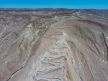
An aerial view of Ma’aleh Akrabim.
“Opening the road will help tourism, hikers, bicyclists,” Tzur says. “It will help tourism throughout the Arava. The road is critical for us and for all Israelis. It’s one of the most beautiful roads in the country, with history and with heritage, and it’s closed because of bureaucracy.”
Shahar Shilo, a tour guide, lecturer and the director of tourism at the Ramat Negev Regional Council, explains: “The road and the ascent to the top have very great importance for what we call the ‘southern product.’ The road makes for a short and fascinating juncture between the central Arava and Yeruham. A detour on Route 25 takes over an hour … It has the ancient and the modern Israeli history, and countless stories are hidden here. For example, the fact that members of the [pre-state underground militia] Lehi, who after the founding of the state joined the Combat Engineering Corps of the Israel Defense Forces and participated in the road’s restoration, concealed in the support pillars of each of the hairpin turns a rock on which they had chiseled the Lehi emblem. Over time, these stones disappeared, and to the best of my knowledge only one remains. There are loads of stories like these about this special road.”
Liat Aviely of the nonprofit organization Zionism 2000 is the director of tourism development in Yeruham. She stresses Ma’aleh Akrabim’s importance to the town, and says the town is doing all it can to press for the road’s reopening. “Transportation Minister Merav Michaeli visited Yeruham a few weeks ago and the issue was raised with her,” Aviely says. “We made it clear that it’s important for the development of Yeruham tourism. She seemed excited about the topic, which isn’t new to her, and said the ministry will examine it in a positive light.
“For us, it is an important link between Yeruham and the Arava. We’re the gateway to the hiking trail,” she adds. “It’s one of the most traveled routes in the south. Reopening the road will increase the number of visitors to Yeruham. These are amazing places and we don’t get to them enough and don’t know them well enough.
“It should be kept in mind that this is soft tourism. These are visitors with the character of hikers. For them, Yeruham is a star town, from which there are many routes to take. The road’s nature must be preserved; it mustn’t be turned into a regular road. The driving experience on the switchbacks is important, as well. We have seen this in many places abroad.”
In a written response, the Transportation Ministry said that Ma’aleh Akrabim was closed due to serious safety deficiencies that could endanger people. “The ministry intends to restore the road in cooperation with the relevant local authorities,” the ministry stated. “Ministry representatives conducted several tours and met with the Arava Regional Council. Our ministry endeavors to schedule an additional meeting with council representatives. In the near term the road will remain closed to vehicles, and only hikers will be able to enjoy the views in the area.”
Lots of words. Good intentions. The language of lawyers and bureaucracy. In the end, there is a spacious, beautiful, open desert. From which you can descend from the top of the mountain, at an altitude of more than 400 meters, to the Arava, 350 meters below, along an ancient, marvelous road that leaves the traveler with a sense of adventure. Let us drive.